


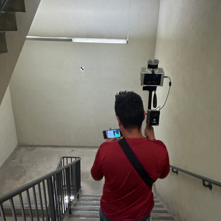
Today, Juan Wee of Kudan USA performed the interior scan with our local ambassador, Eunice Estonactoc, SAIT geomatics student and CanSLAM Volunteer. Eunice got to experience the DevKit scanner in operation with Kudan's Juan Wee walking her through the operation of the system.
The DevKit system currently has two variants; both LiDAR-based SLAM solutions that can accept other sensors, like the optional GNSS sensor, to enrich and refine the data collection process. While one variant is equipped with the Ouster OS0/1-128 LiDAR array, the DevKit that we were introduced to is equipped with the Ouster OS0/1-64 LiDAR array.
Scan Lines: 64 individual channels
Range: 35 metres @ 10%, 75m @ 80%
Points per Second: 2.6 Million
Precision: ±0.001 metres (1 cm or 4/10 of an inch)
Sales Rep: Juan Wee, juan@kudan.eu, +1.312.480.9010
Juan was able to effortlessly collect the interior area of Heritage Hall with his turnkey solution, monitoring the data collection through a remote connection on his smart phone. The system is completely self-sufficient in that it does not require any other supporting systems to become your spatial mapping device and point cloud alignment/exporting tool. The only reason he wasn't able to give us the point cloud on the spot was because we didn't have the target coordinates for him!
For more information on Kudan USA and the DevKit, you can access read the pamphlet provided, visit their website at kudan.io , or see their information in the CanSLAM report at the GoGeomatics Expo in October.
A whole-hearted thank you to Juan and Kudan for sharing your product with us! We look forward to seeing the data!
And another thank you to our diligent student volunteer, Eunice Estonactoc, for being such a wonderful host :)


Комментарии