What We Deliver
The direct value to any interested industry are the data sets produced through scanning for the event. With these samples, we can evaluate performance, adopt machine learning and computer processes, and refine these incredible systems.
-
Data Sets on Cloud (& Cloud Platform?)
-
Control Set (Network report, control scan)
-
Raw mission data, GNSS Base Station Data
-
Uncontrolled SLAM point cloud (intensity only; LAS1.4)
-
Controlled, post-processed data (Any/All data associated; LAS1.4, JPEG, Undistorted JPEG, trajectory, processing logs, …)
-
-
Report
-
List of available SLAM Devices
-
List & profiles of assessed SLAM Devices
-
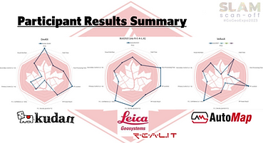
Tables & Graphs of results – Key assessment criteria
-
CREDIT – Individuals & organizations
-
-
Presentation
-
Promote data presence & increase awareness to any relevant industry
-
Slides based on Report images, Tables & Graphs
-
While presentations can be custom made to address industry paint points and outline benefits, the first presentation of results is help at the GoGeomatics Expo in Calgary every year.